Medium · H07
Karaalnitsa / Karaalanitsa Waterfall
Around 5 hours walking
13.6 km · ↑ 570 m · Return walk
From Coliving Semkovo
Regular walkers who can sustain a five-hour forest-road day.
View route and mapA steep, unmarked climb from Karaalanitsa meadow leads through forest and dwarf pine to the lower Skalishki Lake.
Confident mountain walkers on steep, faint paths; road access is extra. Arrange access to Karaalanitsa meadow; roughly 7 km of rough road each way is extra. Vehicle access depends on the road and park restrictions.
Follow the line marked H04. Return walk.

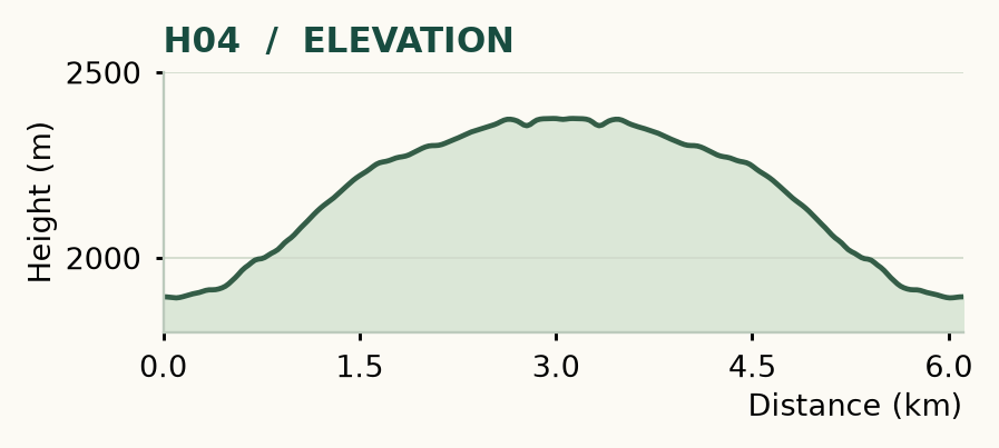
Distance and ascent above follow the mapped route using terrain-model heights. Elevation: 1892–2376 m.
Start/finish: Karaalanitsa meadow, 42.065874° N, 23.487047° E. 3.05 km each way · allow about 2½ hours up and at least 1 hour down · steep, unmarked mountain path. The approach from the resort is roughly 7 km of rough road each way, additional to the lake walk.
Mapped profile: 6.11 km, 520 m terrain-model ascent. Original guide estimate: 3.05 km each way; no ascent figure is given in the opening summary. Both describe the lake walk from Karaalanitsa meadow; the roughly 7 km rough-road approach each way is additional.
Return walk · 6.1 km. Rounded labels on the original map or profile may differ slightly. The original guide estimates are retained here for comparison; use the full figures for your chosen starting point.
Who it’s for: Experienced. Confident mountain walkers on steep, faint paths; road access is extra.
Skalishki feels wilder than the better-known lake outings. The path is faint in places, the climb is sharp and the sense of arrival is all the better for it. Arrange access to Karaalanitsa before you leave Coliving. If you walk the road approach too, this becomes a long day of roughly 20 km, rather than a short six-kilometre excursion. Vehicle access depends on the road and park restrictions; a normal car is not a safe assumption.
The way: start by the old buildings, broad meadow and tiny pond. Before the rough road bends uphill to the right, take the left-hand cairned path. Climb through the forest, then follow the clearer corridor through dwarf pine to the lower lake. Return the same way, watching for the path through the trees.
Do not rely on cairns alone in poor visibility. The continuation over Rejepitsa to Vapski Lakes is an advanced traverse, with a steep link from lake basin to ridge. Save it for a separate day with someone who knows the line; it is no shortcut home.
Medium · H07
Around 5 hours walking
13.6 km · ↑ 570 m · Return walk
From Coliving Semkovo
Regular walkers who can sustain a five-hour forest-road day.
View route and mapMedium · H06
2½–3 hours
9.4 km · ↑ 350 m · One way
From Coliving Semkovo
Regular walkers comfortable with a long descent; arrange a pickup.
View route and mapMedium · H02
4–6 hours
9.9 km · ↑ 540 m · Return walk
From Coliving Semkovo
Regular walkers comfortable with a steep forest climb.
View route and map